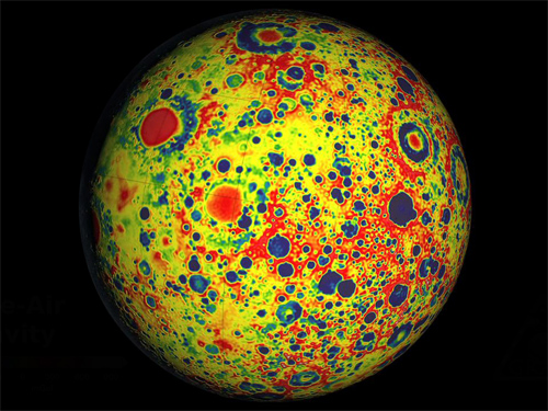
13th January 2013 Moon video from NASA's GRAIL mission The Gravity Recovery and Interior Laboratory (GRAIL) was a NASA mission that ran from March-December 2012, featuring twin spacecraft orbiting the Moon. These used gravitational field mapping to study its interior structure, producing the highest resolution gravity field map ever obtained for a celestial body. This was achieved by measuring tiny changes in the distance between each probe – as small as 1/10th of a micron. In unprecedented detail, the maps revealed an abundance of features never before seen – such as tectonic structures, fractures, volcanic landforms, basin rings and crater central peaks. In addition, the bulk average density of the Moon's highland crust was found to be substantially lower than previously assumed. It is hoped that this data will provide a better understanding of how Earth and other rocky planets formed and evolved.
Towards the end of their mission, the GRAIL spacecraft began to operate at lower orbital altitudes. On 17th December, traveling at 3,760 miles per hour (6,050 km/h) they were deliberately crashed onto the surface. Three days prior to this planned impact (on a mountain at the lunar north pole), mission controllers activated two cameras, taking footage of the Moon's far side. The video below was released by NASA's Jet Propulsion Laboratory this week. For more information, visit the mission home page.
Comments »
|