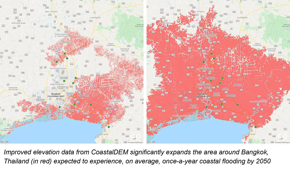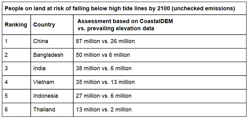
1st November 2019 New study triples estimate of people affected by future sea levels A study in Nature concludes that rising sea levels will threaten 300 million people by 2050, more than triple previous estimates. The upward revision is based on the use of a multilayer perceptron – a class of artificial neural network (ANN) – which analysed topographical maps in finer detail than before. This provided more accurate land elevations, accounting for biases such as tall buildings, trees, and other structures that resulted in overestimates for land height in previous models. The published study takes individual assessments of 135 countries across multiple climate scenarios and years. Asian countries are found to have the biggest potential increases in threatened land. Even with moderate reductions in greenhouse gas emissions, areas within six Asian countries (China, Bangladesh, India, Vietnam, Indonesia, and Thailand) where 237 million people live today could face annual coastal flooding by 2050, roughly 183 million more than assessments based on prevailing elevation data. Without existing, augmented or new coastal defences, the populations in these areas may face "regular flooding or permanent inundation" within 30 years, according to study authors Benjamin Strauss and Scott Kulp.
"These assessments show the potential of climate change to reshape cities, economies, coastlines, and entire global regions within our lifetimes," said Kulp, CEO and Chief Scientist at nonprofit news organisation, Climate Central. "As the tideline rises higher than the ground people call home, nations will increasingly confront questions about whether, how much, and how long coastal defences can protect them." The main elevation dataset used for previous coastal research – NASA's Shuttle Radar Topography Mission (SRTM) – measures elevations of surfaces closest to the sky, such as treetops and rooftops, whenever they block the ground. Consequently, as Strauss and Kulp explain, it overestimates coastal elevations by more than two metres (six feet) on average, and more than four metres (13 feet) in high-density urban areas, indicating false safety from floods and sea level rise. CoastalDEM, the new AI-based system they developed, reduces these errors to just ten centimetres (four inches) on average. Only a handful of nations have collected and published more precise elevation data than SRTM, generally based on airborne lidar; CoastalDEM was calibrated and validated using mainly these data. "It turns out that for most of the global coast, we somehow didn't know the height of the ground beneath our feet," said Dr. Strauss. "We were shocked to find how much more vulnerable our coasts are than researchers had previously thought. But this also means there are much greater benefits to reducing climate pollution and slowing sea level rise." By the end of this century, assessments based on CoastalDEM find that without defences, land now home to as many as 420 million people worldwide could be vulnerable to annual coastal floods, even if moderate cuts to carbon emissions are achieved. The estimates summarised here are likely to be conservative because they are based on standard sea-level projections and reductions in carbon emissions – in line with 2015 Paris Agreement targets – which worldwide efforts to date are not on track to achieve. Estimates based on unchecked emissions and the potential for early-onset ice sheet instability project that sea level rise could threaten areas where as many as 630 million people now live, 340 million of whom are on land forecast to fall below the high tide line by 2100.
Comments »
If you enjoyed this article, please consider sharing it:
|